Designing an effective air quality management plan for a city requires robust data on the sources of air pollution. The Air Pollution Knowledge Assessments (APnA) city program is an attempt to fill the vacuum of information by creating a baseline of air pollution related information for Indian cities. This is a necessary starting point for policy makers, academic researchers, and citizens to chart out strategies for better air quality. We believe that establishing the baseline or quantifying the extent of the problem in cities, other than the metropolitan cities, is the starting point for change.
In order for us to understand spatial and temporal trends of urban air pollution, we require a robust continuous monitoring network covering all the key air pollutants and all the representative areas of a region.
This is often the bottleneck in countries like India. In the past, we have documented India’s need for 4,000 continuous monitoring stations to spatially and temporally represent air pollution. This number varies between cities and states.
For example, the city of Bengaluru needs 41 continuous monitoring stations to represent an air shed covering approximately 60 km x 60 km. However, this does not represent every 1km x 1km grid in the domain, which is possible only through emissions and
chemical transport modelling.
While it is not a substitute, a detailed emissions inventory coupled with fine resolution meteorological data, processed through a chemical transport model can help fill this gap. This process needs to go through a validation step.
We use WRF-CAMx combination for all the chemical transport modelling. This is a class apart from AERMOD — mathematically and computationally. All the Environmental Impact Assessment (EIA) works in India are required to do AERMOD modelling, which accounts for the model’s commercial demand. However, I have never used this model.
Limited number of stations provide limited validity to modelling outputs. This is a bottleneck which can be addressed only through an increase in monitoring. When
considering forecasting results, it is important to note that the only way to refute modelling outputs is through a better monitoring network. Therefore, it is up to the PCBs to counter modelling results. We can improve inputs and outputs if monitoring data is available.
Once the validity of the emissions inventory is established, it can be used to simulate what-if scenarios for various sectors. The results can be used to formulate and prioritise options at both spatial (city/state/nation) and temporal scales (days/months/years).
“Air Quality Forecasting System (AAQFS)” (Point 9.5 of National Clean Air Program) envisions daily forecasting of air quality and early warning system through “state-of-the-art” modelling system. In your opinion, how robust is the government’s plan to take up this initiative and what are the fallouts?
It is hard to comment on this because there is little-to-nothing known about the government’s plan. NCAP only says that a forecasting system is envisioned, refraining from providing any further details.
In the chemical-transport modelling field, the biggest bottleneck is getting the emissions right — both in space and time. Every group has their own method in developing these models using the resources available to them. However, challenges arise when modelling urban-scale simulations (1km). Traditionally, most of the groups run global models using global inventories at coarser resolutions (typical 1-deg = 100-km) or regional models using the global inventories at coarser resolutions (like 10–25–36–54- km), which averages out any of the discrepancies in the inventories. The outputs look reasonable enough to proceed to the next steps — evaluations and analytics. In the past, computational space used to be a challenge, which is now nullified with the presence of cloud computing and high performance systems for hire. The user groups for the state-of-the-art models are also more populated than before, which makes it easier to connect with other users who may have faced similar challenges in setting up and running these models.
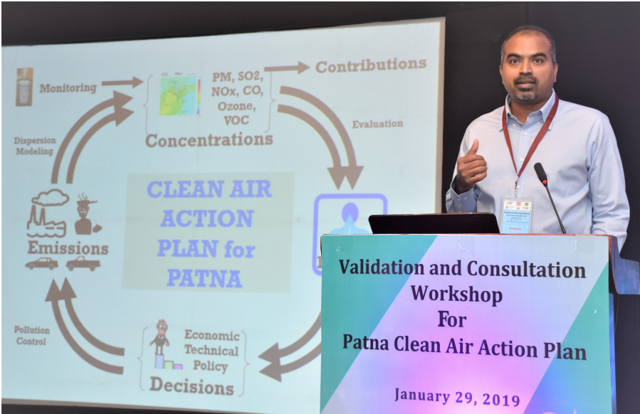
Dr Sarath Guttikunda is the founder of UrbanEmissions.Info (UEinfo, India). His main research interest lies in urban emissions and finding ways to bridge the gap between science, policy, and public awareness. In this interview, he speaks about the APnA city program and his work in dispersion modelling to understand spatial distribution of pollutants.

Just over a year ago, an artificial intelligence (AI)-generated recreation of Sir...
With India’s Carbon Credit Trading Scheme (CCTS) expected to become fully operational...

Recent tensions around the Strait of Hormuz and the ongoing effects of...

From 1 April 2026, the Solid Waste Management (SWM) Rules, 2026, will...

In our ‘Thinking in Models’ series, we draw on insights from NITI...
This article is part of our ‘Thinking in Models’ series, which reflects...